NB: Thanks to a kind German researcher whose inquiry prompted me to update this page.
Tuesday, April 30th. 2019
My mistake. Not siderite. Thanks to everyone who tried helping.
Had a great talk about my mystery rock with two people at the Geosciences Department of University of Nevada at Las Vegas here in town. Kind and informative folk. What follows is NOT the exact wording of what they told me, rather, my interpretation of their remarks as a collector and a rockhound. Any mistakes or poorly put remarks are my own.
For background, the relevant map is the Preliminary Geologic Map of the Irish Hill 7.5 Quadrangle, Amador County, California. The loose rock I carried in, as well as the larger outcropping I have photographs of at my website, is at the contact between two parts of what is called the Gopher Ridge Volcanics, Jgo, and Jgof, respectively.
This is from the map:
Gopher Ridge Volcanics (Late Jurassic)—Named by Clark (1964) for exposures along the Calaveras River south of the quadrangle. Consists mostly of massive mafic and intermediate tuff, breccia, and occasional greywacke and agglomerate. Likely Oxfordian in age (Clark, 1964). Includes felsic facies (Jgof) that was originally mapped as quartz porphyry by Turner (1894) and Taliaferro (1943).
After careful examination and handling of the large rock and associated small samples showing the interior of the rock, these are some of their observations.
1. Streaks red for hematite. Rock most likely an association of hematite and goethite.
(I hadn’t streak tested because it seemed the powdery, iron-rich red coating cold only produce a red streak)
2. The large rock seems severely eroded on one side by preferential weathering.
3. A thin quartz vein appears to run through the width of the large rock.
4. Some of the large rock may have originated as a conglomerate and was then altered heavily by hydrothermal activity.
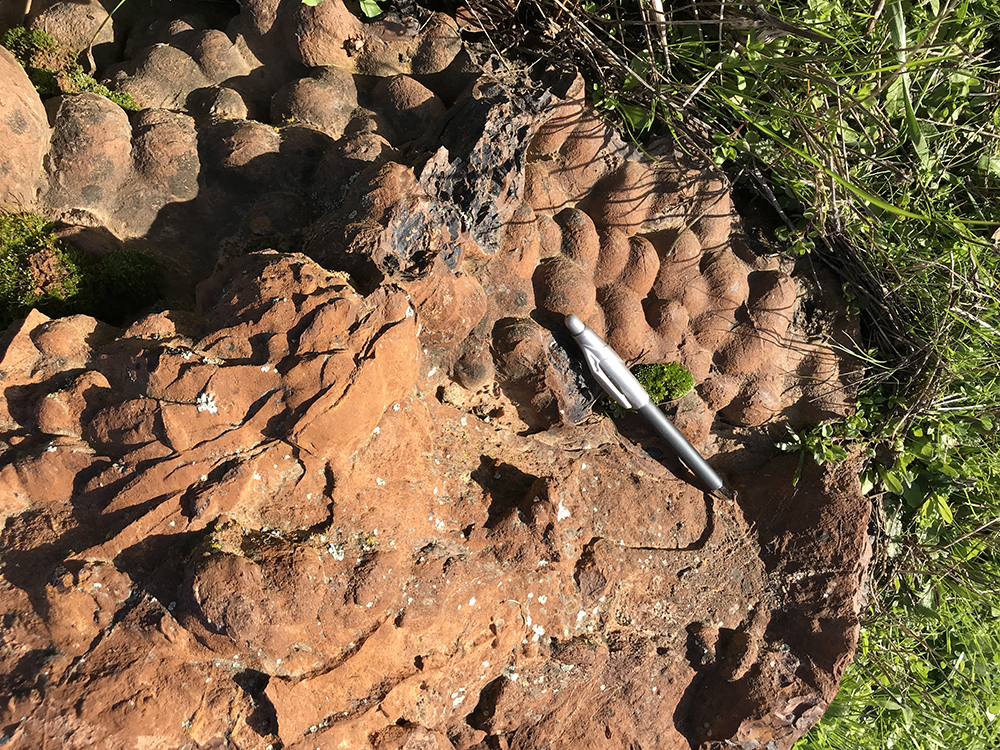
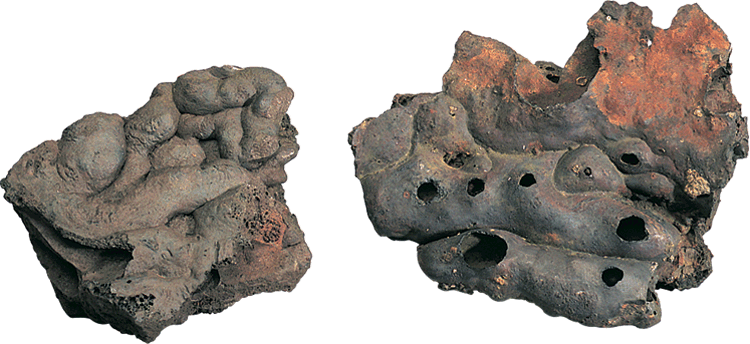
5. My microscope photographs of the interior, showing a botryoidal texture, are exactly what they would expect given the texture of the rock’s exterior.
6. Isolated outcroppings like this may exist by themselves without like them around. It is possible other material like this is below the surface, covered.
7. Not slag or manmade occurrence
That’s all I have for now. A beautiful outcropping that certainly deserved the time to be looked at and discussed. A suggestion was made to saw the large rock into two pieces and I am thinking about it. The rock may yet reveal more.
Side note. These were Rolf’s comments which the people at UNLV found informative:
Hi Tom,
From Rolf Luetcke:
I looked at the photo you sent and to me at the lower left I saw something that to me looks like goethite. It is a seam and a bit hard to see in the photo but it looks to me like a fibrous inner structure to the seam. To me that means goethite. Could be a mixture of the iron oxides, which wouldn’t necessarily give a metal detection on equipment but sure seems like a botryoidal iron, either goethite or hematite-limonite.
Dear Rolf::
I think you may be onto something. Under my 10X loupe I can see what are definitely threads or fiberous material that looks like thick strands of hair. The Geosciences Department at the University of Las Vegas has asked me to bring in any info I have on the rock so I will print out your thoughts. There is a picture of goethite with hematite at Mindat that looks like my rock, although the specimen photographed is quite small. Now, the most important question, how does one pronounce goethite? Is it gur-tite or something else?
Here’s photo showing botryoidal texture on the interior:


ORIGINAL POST:
This odd looking lump is on my friend’s horse ranch on Carbondale Road, outside of Plymouth, California in rural Amador County. Near the center of California’s Mother Lode Country. I wrote about this place in a previous post. The soil is nondescript, red foothill clay, with the most common rock underfoot being broken pieces of iron stained quartz.
And then there is this thing, which my first guess was a bunch of leftover concrete that someone had attempted to color. Perhaps they dumped out their concrete mixer at this spot? There is no sign of any unusual concrete work in the area, but who knows? I did not have my rock hammer as I was traveling and renting a vehicle.
Usually concrete aggregate has much smaller stones than the blobs we see here. I am up to any guesses. There is a creek nearby with what I presume are rounded stones but it is not on my friend’s property so I haven’t checked it out. I can’t imagine anyone making their own concrete with locally collected rock, think of the work, but I suppose it is possible.
Another possibility is siderite, which Mindat.org lists as being in the general area. A nice man named Brice on the Facebook group, Rocks and Minerals - identification and information, made this suggestion.
Siderite is an iron mineral, of which I am only now reading about. Apparently, siderite is valuable mineral in theory since it contains a high amount of iron, possibly 48%. In such a small outcropping it is totally uneconomic but an interesting curiosity to any rockhound or mineral collector walking the woods. Its presence may lead to the discovery of other nearby minerals such as manganese.
The odd looking lumps may be large siderite crystals that have weathered to their present shape over time. More on that below.
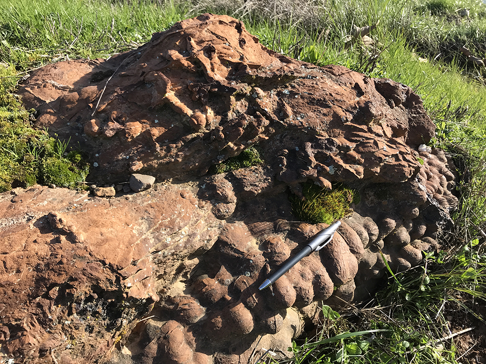
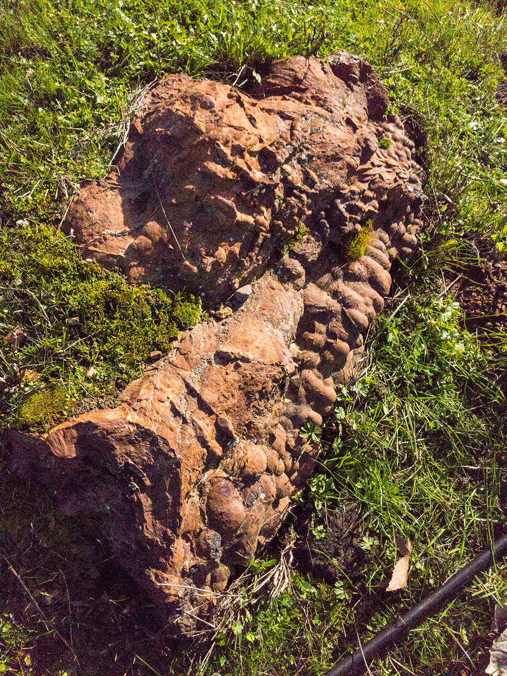
This is an overall view of what I will call for now, the outcropping. For a much larger picture to ponder over, click here. Or click on the photo itself.
Closeup photograph. Pen for scale.
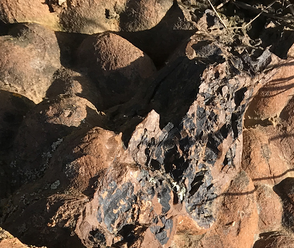
A damaged or otherwise altered section of the outcropping. Broken concrete doesn’t turn black, it retains a whitish color due to the Portland cement. If the concrete were mixed with a colorant originally, however, in the drum, the color would run throughout the mix. But you would have one color, and not two as in the photo. An iron ore deposit just might make sense. The outer layer has weathered and oxidized red, rusted if you will, while the more newly exposed material has yet to change.
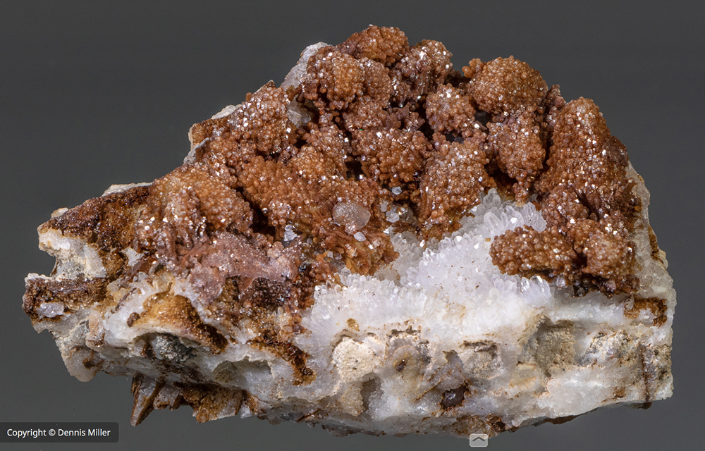
The above picture is courtesy of Dennis Miller. Used with permission. It’s siderite from an area near Chihuahua, Mexico. Note the globular forms. I’m speculating that the globular material in the outcropping I came across are weathered, eroded permutations of this siderite’s original form. Or not.
The Henry Holt Guide to Minerals, Rocks, and Fossils (very British) says that siderite crystals can be, “[M]assive, fibrous, compact, botryoidal, or earthy.” The outcropping seen here is definitely botryoidal.
The book goes on to say that massive siderite is widespread in sedimentary rocks. There are notable, economic clay deposits several miles distant, which leads me to this quote from Holt’s book.
“Massive siderite is widespread in sedimentary rocks, particularly in clays and shales where it forms clay ironstones which are usually concretionary in origin.”
Concretionary. And an outcropping that looks like concrete. Iron stains every piece of broken quartz on the ground. So iron must be in the soil. Can anyone put this all together?
Mindat doesn’t show siderite as found in Amador County, however, these reports are usually confined to recording occurrences of economic value. Or a citation in the scientific literature. Like in a geology report. Not all outcroppings everywhere can possibly be recorded. Siderite has been reported in the county of El Dorado, immediately north, and Calaveras, immediately south. In the plant world, we would call an occurrence in a new area as a range extension. And you thought rocks and minerals had a peculiar vocabulary!
There is a mineral deposit of economic nearby, in fact, two. The named one is a copper deposit with the odd title of Mutual Life Insurance, Record ID 1016243. That can be looked up with the Mineral Resources Data System or MRDS. The closest point to these two spots is at the end of Poppy Hill Lane, which branches off of Forest Home Road. Although Google Maps shows some conflict with that, Poppy Hill being off of Long Gate Road.
I will have a friend test the outcropping with a magnet. That may be diagnostic. Although I see on Mindat that siderite is paramagnetic, a new term for me. It essentially means weakly magnetic. I’ll mail my friend one of my rare-earth magnets. Maybe that will make a difference in testing. I’ll report back later. Thanks, again, Dennis, for the photograph.
And here’s a citation to a paper that is beyond my understanding. The example labeled “D” is interesting. These are examples from Washington State. “Excrement-shaped masses of siderite and limonite have been reported from clay-rich sedimentary rocks . . . ” Click on the image for a larger picture. All the information is from the providing site.
Figure 3. Miocene siderite specimens from Salmon Creek, Washington. A, B, C, E, and G are coprolite-like extrusions that show pointed ends and longitudinal striations; D is a botryoidal concretion; F is an extruded mass with botryoidal encrustations.
Enigmatic origin of ferruginous “coprolites”: Evidence from the Miocene Wilkes Formation, Southwestern Washington - Scientific Figure on ResearchGate. Available from: https://www.researchgate.net/figure/Miocene-siderite-specimens-from-Salmon-Creek-Washington-A-B-C-E-and-G-are_fig1_249527075 [accessed 21 Feb, 2019]
The geologic map of the area, however, points to volcanic origins, igneous rock, not sedimentary. Minerals.net states that siderite can be in igneous, sedimentary, and metamorphic rock.
Preliminary Geologic Map of The Irish Ill 7.5 Quadrangle, Amador County, California:
ftp://ftp.consrv.ca.gov/pub/dmg/rgmp/Prelim_geo_pdf/IrishHill_24k_v1.0.pdf
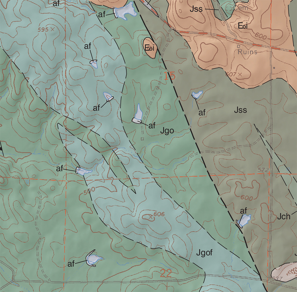
Outcropping exists at the border of Jgo and Jgof.
From the geologic map:
Gopher Ridge Volcanics (Late Jurassic)—Named by Clark (1964) for exposures along the Calaveras River south of the quadrangle. Consists mostly of massive mafic and intermediate tuff, breccia, and occasional greywacke and agglomerate. Likely Oxfordian in age (Clark, 1964). Includes felsic facies (Jgof) that was originally mapped as quartz porphyry by Turner (1894) and Taliaferro (1943).
Note: af stands for artificial, man made workings. Outcropping not close. But what about forge slag? That would make this outcropping an archeological find, not a geological find, although the two would be related. Look at the picture below:
Source of the forge slag photo: http://bertan.gipuzkoakultura.net/es/16/en/1.php
Perhaps the “af” in the geological map suggests other former forge placements, these would have to date back to the gold rush era, certainly before electrical power was available to work iron ore in a modern forge.
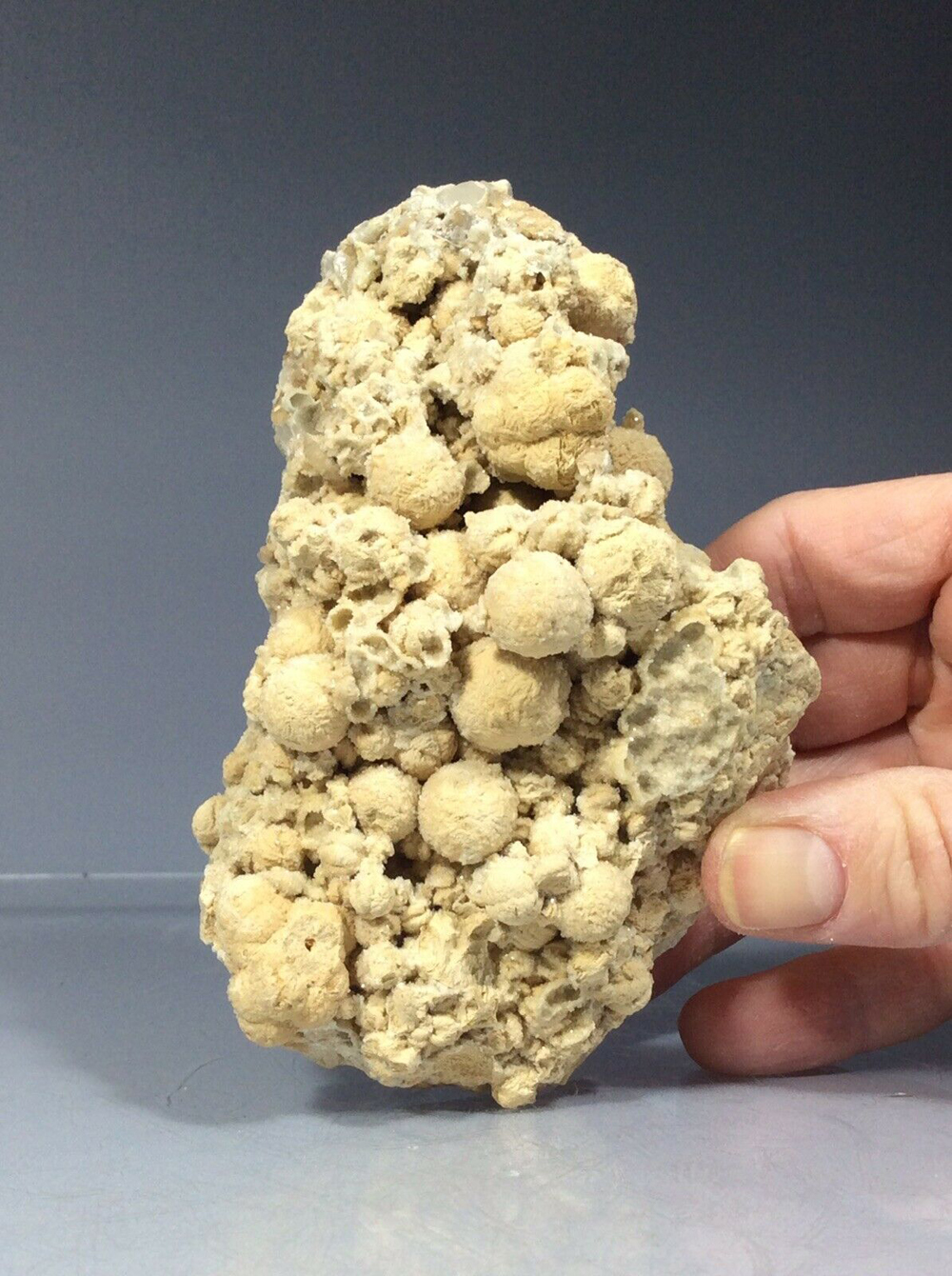
Interesting photo from eBay below. “‘Siderite “Balls” with Calcite (Nikolaevskiy Mine, Dalnegorsk, Russia).”